The Map
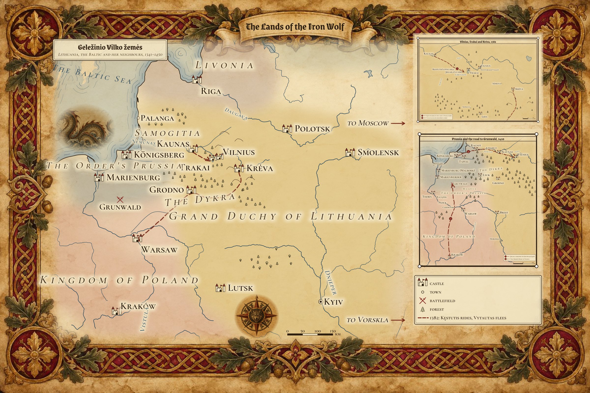
The Lands of the Iron Wolf, in Lithuanian Geležinio Vilko žemės: Lithuania, the Baltic and her neighbours, 1341–1450. The main map names only the places a reader needs at a glance. Click any named place that has a page in this wiki to open it; hover over it, or move to it with the Tab key, for a short note. The two insets below show the saga’s closest country at a larger scale, and the table at the end lists every place.
Larger image · Black-and-white print version
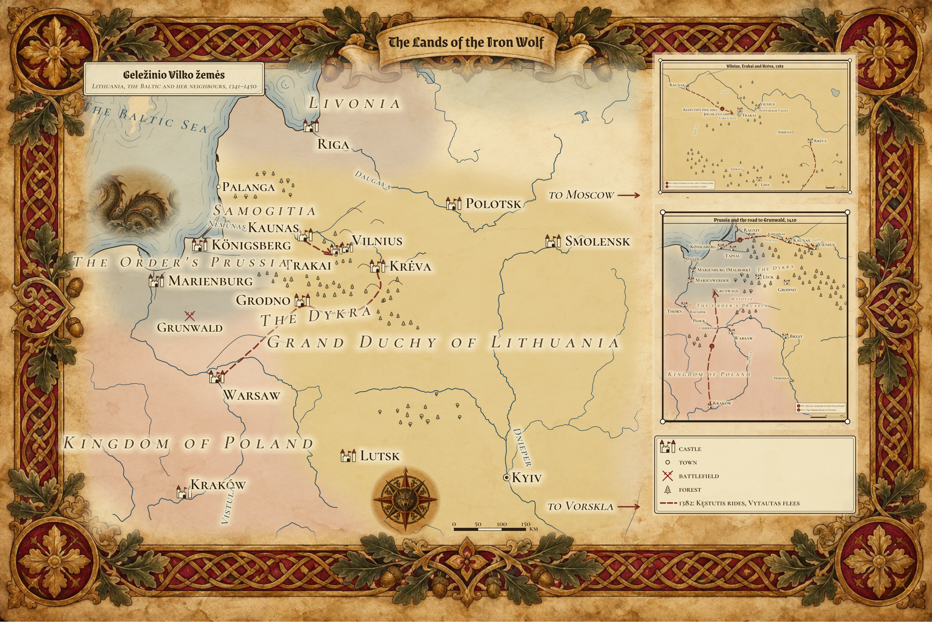
Inset 1: Vilnius, Trakai and Kreva, 1382
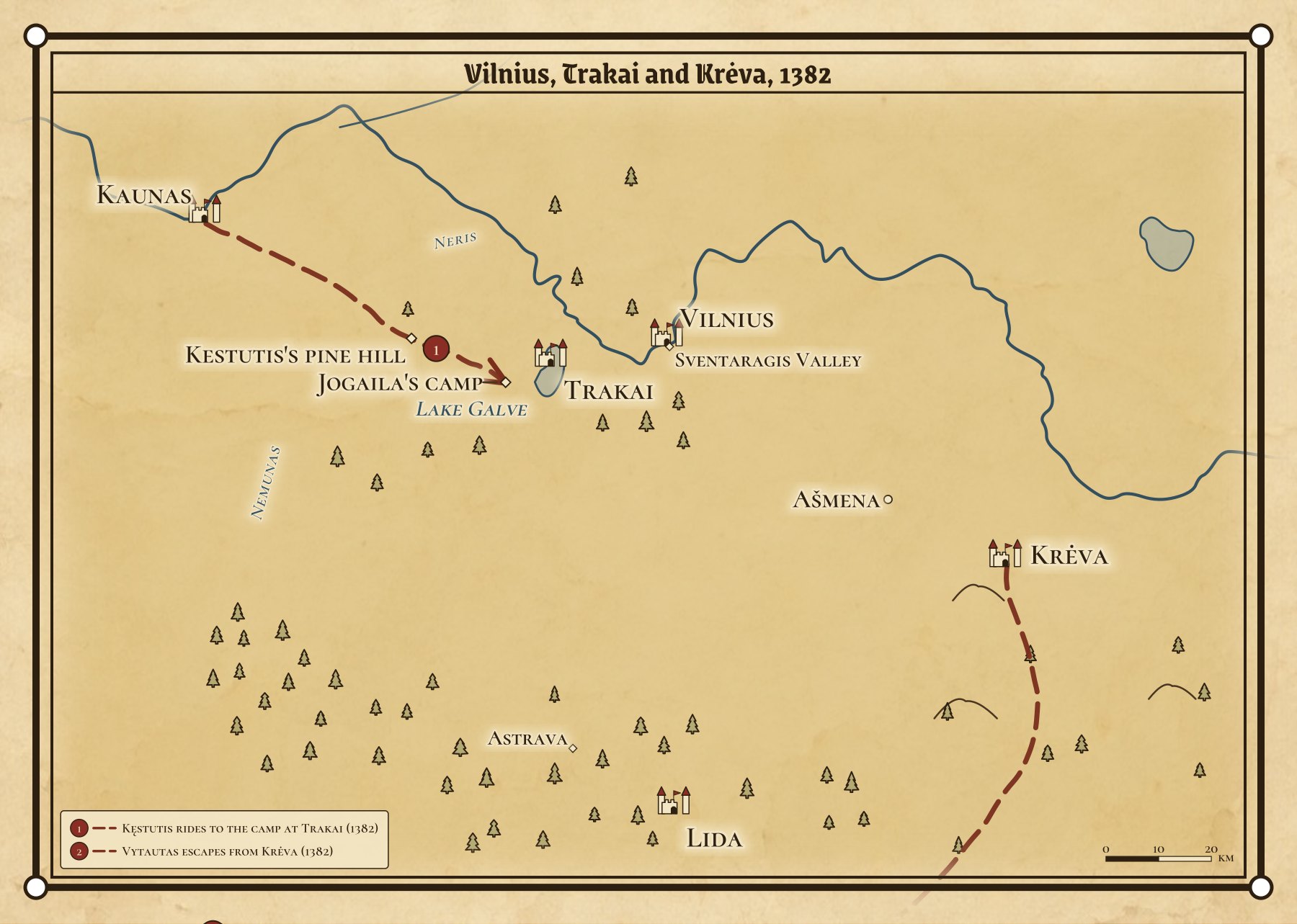
The camp between the lakes and the pines where Kęstutis and Vytautas were taken on 3 August 1382 (Jogaila’s camp, the road to it), the ride that led there (1), and Vytautas’s flight from Krėva in the autumn (2). The camp and the pine hill are the saga’s places: their exact spots are not in the record. Larger image.
Inset 2: Prussia and the road to Grunwald, 1410
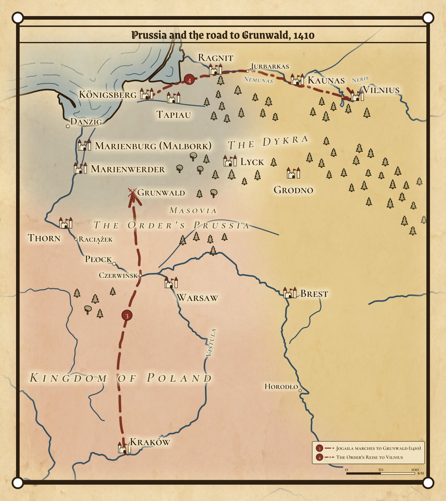
Jogaila’s march from Kraków over the pontoon bridge at Czerwińsk to Grunwald (3), and the road the Order’s Reise took from Königsberg up the Nemunas to Vilnius (4). Larger image.
How to read it
Signs: a castle is a fortified place; a small circle a town; crossed swords a battlefield; a diamond a place that exists only in the saga or whose spot is uncertain; a few small trees mark the great forests, where the Dykra lies between the Nemunas and the Order.
Colours: the soft washes show the lordships about 1430 (Grand Duchy of Lithuania in gold, the Order’s Prussia in grey-blue, Livonia in violet, the Kingdom of Poland and Masovia in red, Moscow in green). They are not borders: the frontiers moved every decade.
The dashed line on the main map joins the two journeys of 1382, Kęstutis’s ride and Vytautas’s escape. The other journeys are on the insets. The ride’s course is the saga’s own (the sources give only its start and end); Vytautas’s route follows the record: Krėva, Masovia, then the Order.
Accuracy: coasts, rivers and lakes follow the real land. Places stand where they really are, except the saga’s own places and those whose exact spot is uncertain; the table below marks them (for example, Jogaila’s camp and Kęstutis’s pine hill are placed by the story, and the positions of Salynas, Pabaiskas and Raciążek are approximate).
Every place on the map
Place |
Kind |
Shown on |
When, and notes |
|---|---|---|---|
town |
inset 1 |
1370s-1390s |
|
site |
inset 1 |
4 Aug 1392; Agreement of Ostrów; the saga puts it near Lida; saga place, position stylised |
|
Brest |
castle |
inset 2 |
Council of 1409 |
site |
inset 2 |
1410; Vistula pontoon crossing, 30 June 1410 |
|
Danzig |
town |
inset 2 |
|
castle |
map, inset 2 |
1432 |
|
battlefield |
map, inset 2 |
15 July 1410 |
|
site |
inset 2 |
Union of 1413 |
|
site |
inset 1 |
20 Jul - 3 Aug 1382; palisaded camp between the lakes and the pines; position stylised; saga place, position stylised |
|
town |
inset 2 |
Georgenburg |
|
castle |
table only |
Podolia |
|
Kaunas |
castle |
map, inset 1, inset 2 |
1362; Order’s raids |
site |
inset 1 |
3 Aug 1382; the pine hill beyond the Trakai lakes; position stylised; saga place, position stylised |
|
castle |
map, inset 2 |
Order’s Reise base |
|
castle |
map, inset 2 |
Jogaila’s baptism 1386; on the Vistula |
|
castle |
map, inset 1 |
1382; 1385; Kęstutis dies, 15 Aug 1382; the Union of 1385 |
|
city |
map |
Skirgaila’s seat 1395 |
|
lake |
inset 1 |
||
Lida |
castle |
inset 1 |
|
castle |
map |
1429 |
|
castle |
inset 2 |
1390 |
|
castle |
map, inset 2 |
Order’s capital; on the Nogat |
|
castle |
inset 2 |
Order |
|
town |
table only |
1417; Samogitian bishopric, 1417 |
|
Memel (Klaipėda) |
castle |
table only |
Order’s castle |
Moscow |
city |
map |
Sofija’s husband Vasily I |
Novgorod |
city |
table only |
|
battlefield |
table only |
1 Sep 1435; on the Šventoji, south of Ukmergė; position approximate |
|
town |
map |
Birutė’s grove |
|
town |
inset 2 |
||
Polotsk |
castle |
map |
|
Pskov |
castle |
table only |
|
site |
inset 2 |
1404; position approximate |
|
castle |
inset 2 |
Order’s Nemunas castle |
|
Riga |
castle |
map |
Livonian Order |
river island |
table only |
12 Oct 1398; Nemunas islet near Kulautuva; position approximate |
|
Smolensk |
castle |
map |
1395; 1404 |
site |
inset 1 |
1345; 1382; 1387; Neris-Vilnia confluence under Gediminas Hill |
|
castle |
inset 2 |
1385 (Vytautas baptised) |
|
Thorn |
castle |
inset 2 |
|
castle |
map, inset 1 |
1382; 1392; Island castle on Lake Galvė |
|
castle |
map, inset 1, inset 2 |
1341-1450; Gediminas Hill; the capital and the Last Flame |
|
Vitebsk |
castle |
table only |
|
battlefield |
map |
12 Aug 1399; river battle; the exact field is disputed; position approximate |
|
castle |
map, inset 2 |
Masovia |
Coastlines and rivers: Natural Earth (public domain).